Wind and Metocean Data
When You Need It
Gain Faster and less costly access to high-quality wind and metocean data without the hassle and risk of procurement and operations.
Earlier Access to Critical Wind Measurements
Early during project development, the uncertainty of the metocean and wind resource conditions is elevated, often due to a lack of high-quality measurements. Having measurements earlier in the development process decreases timelines and reduces energy potential uncertainty.
TGS is introducing a multi-client business model to the industry for offshore measurement campaigns, specifically for deploying floating LiDAR (FLiDAR) buoys. This model ensures that the cost of acquiring measurements is greatly reduced and makes critical wind and metocean measurements available much earlier in the development process, often well in advance of lease round auctions. Data streams are quality-controlled and made available to customers on a daily basis.
Why TGS multi-client Floating LiDAR?
.png)
FLiDAR First
Reduce uncertainty with wind and metocean data available before the lease round.

Reduce Cost
Share the costs with multiple stakeholders.

Hassle-Free
Let us handle the risk of procurement and operations

Environmental Data
Measure bird and bat activity above the buoy and whale and dolphin activity below
About our Floating LiDAR Buoys
We deploy certified floating LiDAR buoys to ensure the highest quality wind resource data. These LiDAR buoy platforms have successfully met or exceeded key performance indicators across multiple validation campaigns, demonstrating the accuracy, reliability, and thus the low uncertainty of the collected wind resource data. Collecting high-quality metocean data is also critically important.
Floating LiDAR Coverage
Select a tab below to find out more.
-
TGS Floating LiDAR Opportunities
-
Public LiDAR Data
-
Lease Coverage
TGS Floating LiDAR Opportunities
- Central Atlantic (2 buoys)
- New York Bight (2 buoys)
- Massachusetts
- Norway: Utsira Nord
- Offshore Germany (2 buoys)
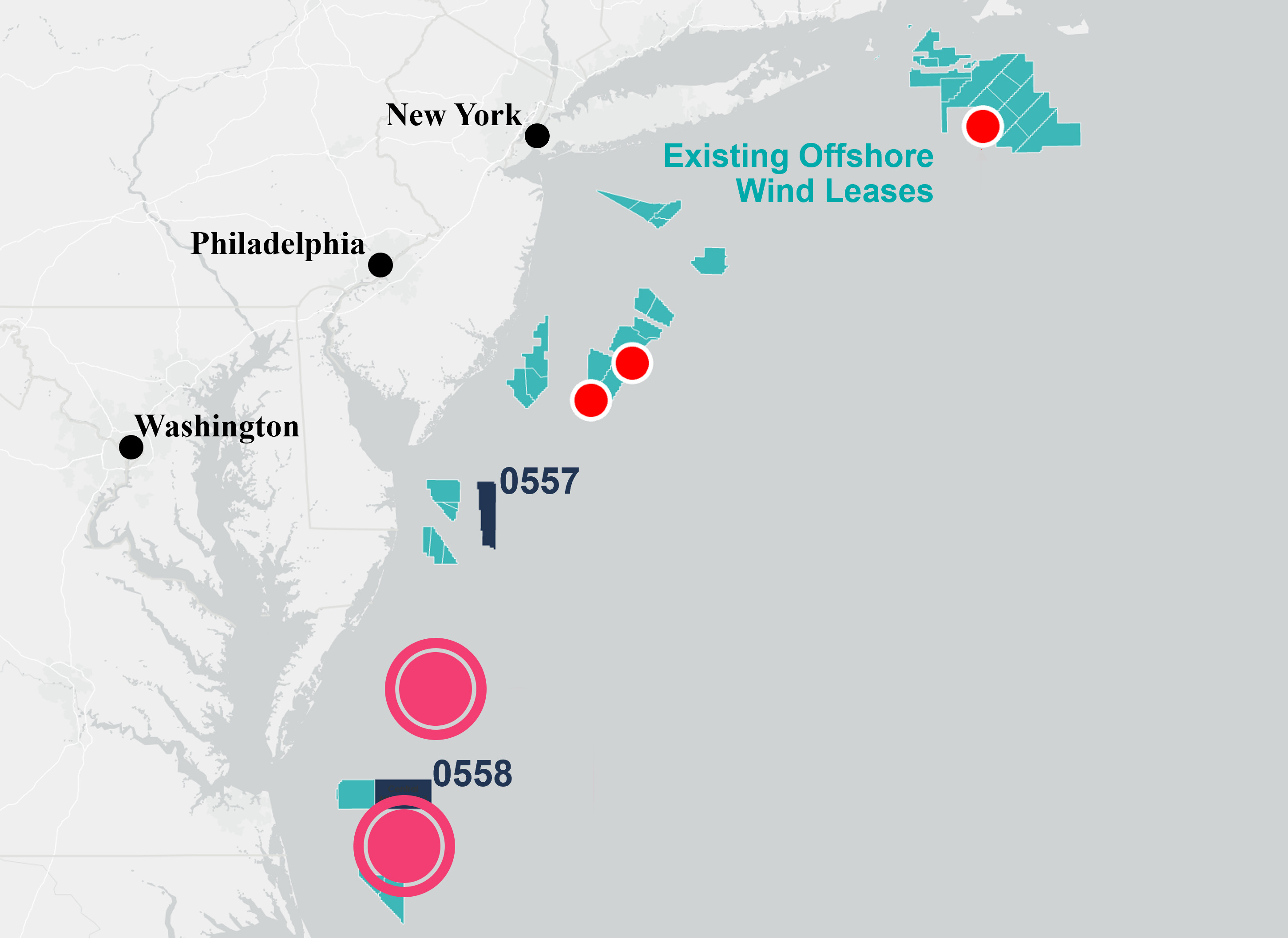
Central Atlantic (2 buoys)
These new, high-quality floating LiDAR will create the only modern and full dataset covering the Central Atlantic lease areas, due to open for bidding in 2024. Access to such data at this early stage is expected to significantly enhance the decision-making ability of all stakeholders investing in the wind development future of this region.
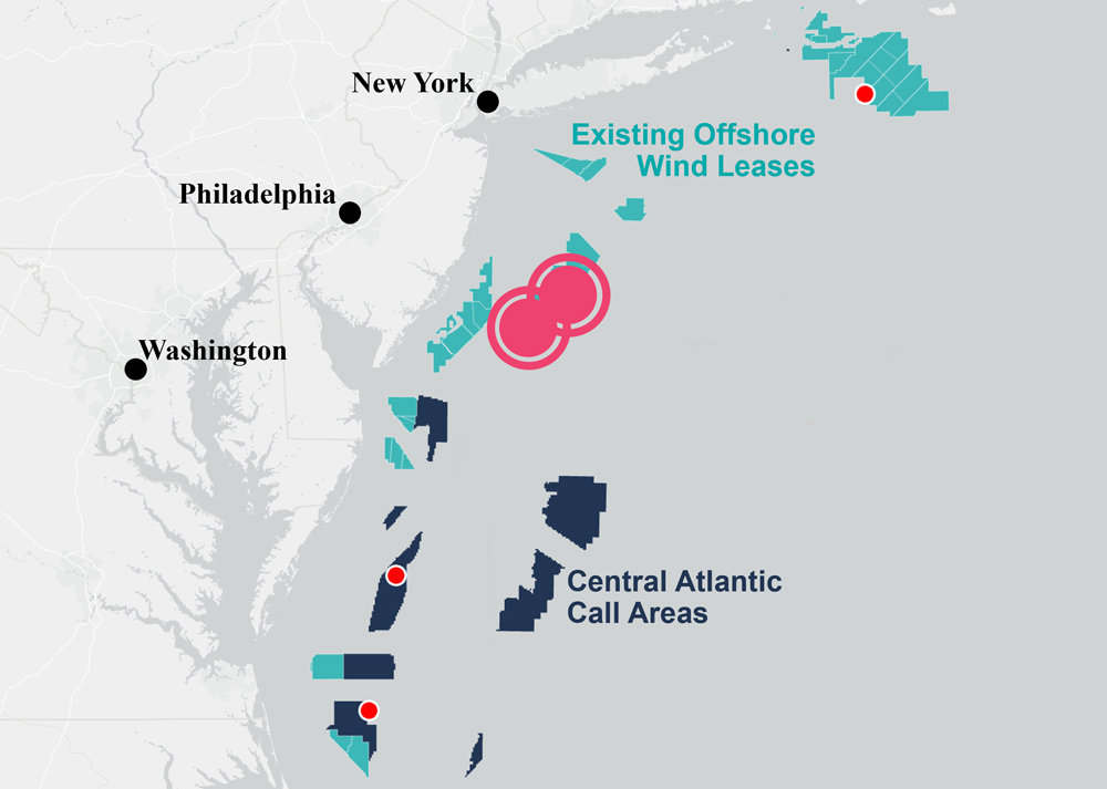
New York Bight (2 buoys)
TGS floating LiDAR buoys covering the NYB lease area will reduce wind and ocean modeling uncertainties and cycle times for those embarking on site assessment activities. It will further validate TGS' expansive high-resolution numerical weather prediction (NWP) model data coverage.
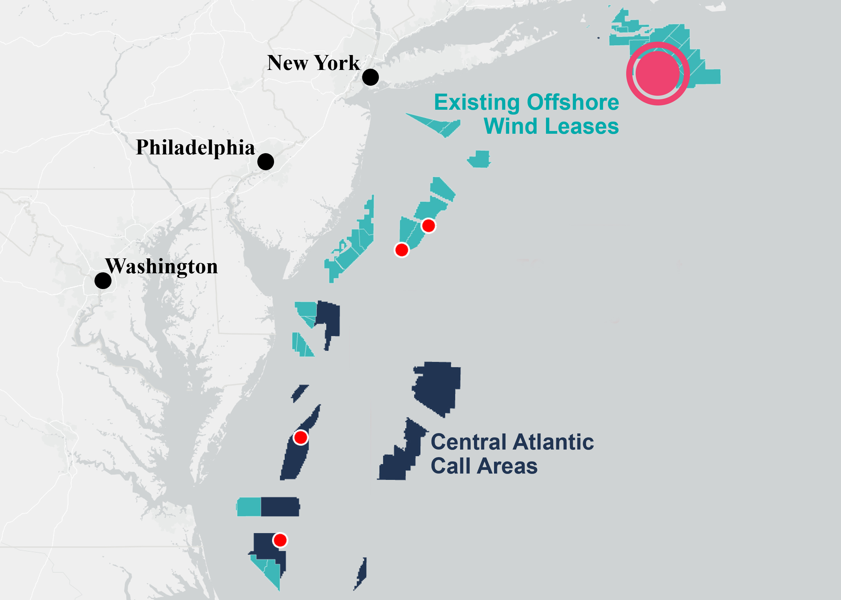
Massachusetts
Our FLiDAR buoy offshore Massachusetts will allow those companies working on wind development in the area to acquire additional stage 3 accredited data to de-risk Final Investment Decisions (FIDs) or enhance Construction and Operations Plans (COPs).
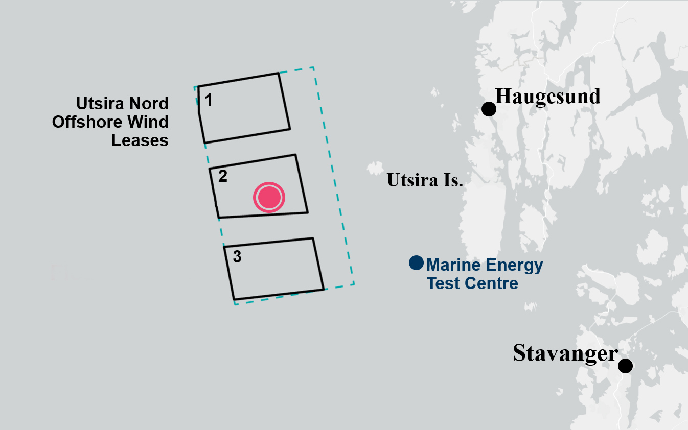
Norway: Utsira Nord
The first-ever floating LiDAR buoy measurement campaign to support Norwegian offshore wind development. Deployed in June 2023, this buoy will enhance decision-making for the three floating wind project areas.
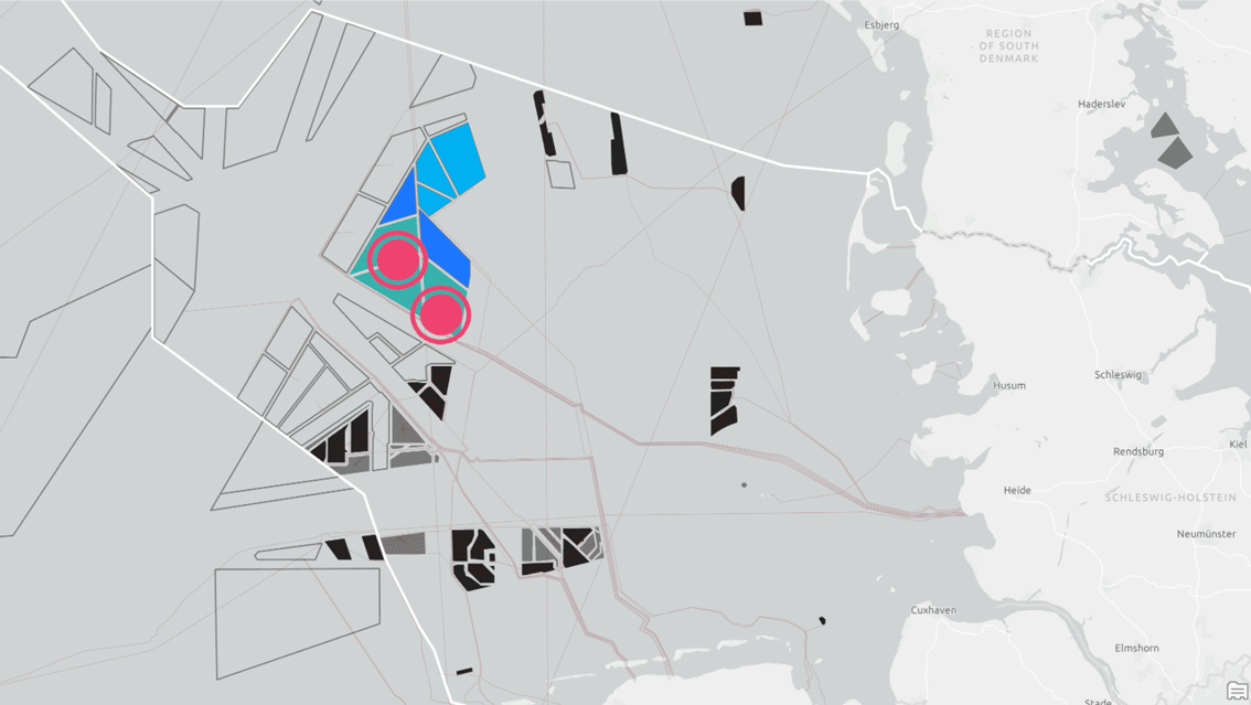
Offshore Germany (2 buoys)
TGS has launched a multi-client wind measurement campaign using LiDAR buoys to enhance decision-making and support several current and future wind lease rounds in the German Bight. The coverage area includes lease areas N-11.2 and N-12.3, offered in the June 2024 lease round and the 2023-awarded lease areas N-11.1, N-12.1 and N-12.2.
Public LiDAR Data
Public Floating LiDAR Data
Besides our multi-client FLiDAR data, TGS also delivers open-source data via Wind AXIOM, our unique wind development insight platform. Open-source FLiDAR data may have periods with low quality or anomalous data. Our quality control (QC) of observational data involves thoroughly reviewing and analyzing the measured values to increase confidence in the data for further analysis and improve trust in derivative datasets, including those based on these measurements, adding significant value. QC of open-source observations by TGS is performed using a multi-set process that includes a final review by expert analysts, not simply relying on automated workflows.
| Device Name | Source Institution | Time Period Available in AXIOM |
|---|---|---|
|
NYSERDA 05 |
NYSERDA |
2019/08/12 to 2021/05/03 |
|
NYSERDA 06 |
NYSERDA |
2019/09/04 to 2021/05/03 |
|
Atlantic Shores |
Atlantic Shores Offshore Win (EDF-Shell) |
2020/02/26 to 2021/04/29 |
|
Martha’s Vineyard |
Woods Hole Institute/MVCO |
2016/08/15 to 2020/09/01 |
|
Virginia Beach |
US DoE |
2014/12/11 to 2016/05/31 |
|
Morro Bay (Ca) |
US DoE |
2020/10/01 to 2022/02/16 |
|
NYSERDA 05 |
NYSERDA |
2019/08/12 to 2021/05/03 |
| Device Name | Source Institution | Time Period Available in AXIOM |
|---|---|---|
|
NYSERDA 05 |
NYSERDA |
2019-08-12 to 2021-05-03 |
|
NYSERDA 06 |
NYSERDA |
2019-09-04 to 2021-05-03 |
|
Atlantic Shores |
Atlantic Shores Offshore Win (EDF-Shell) |
2020-02-26 to 2021-04-29 |
|
Martha’s Vineyard |
Woods Hole Institute/MVCO |
2016-08-15 to 2020-09-01 |
|
Virginia Beach |
US DoE |
2014-12-11 to 2016-05-31 |
|
Morro Bay (Ca) |
US DoE |
2020-10-01 to 2022-02-16 |
|
NYSERDA 05 |
NYSERDA |
2019-08-12 to 2021-05-03 |
Lease Coverage
Lease Coverage - Multi-Client Floating LiDAR
Through our multi-client FLiDAR campaigns, TGS Stage 3 certified floating LiDAR data covers a number of the world's current and future wind lease rounds. The table below indicates the project status of each measurement campaign.
Through our Wind AXIOM Lease Developer subscriptions, this data is available for immediate download in integration into existing regional models.
| Region | Lease Round | Subscription |
|---|---|---|
|
North America |
New York Bight | ACTIVE |
|
North America |
Carolina | In Planning |
|
North America |
Central Atlantic |
ACTIVE |
|
North America |
Massachusetts |
ACTIVE |
|
North America |
California |
In Planning |
|
North America |
Oregon | In Planning |
|
North America |
Maine | In Planning |
|
Europe |
UK |
In Planning |
|
Europe |
Norway |
ACTIVE |
|
South America |
Brazil |
In Planning |
Lease Coverage - Wind AXIOM Subscriptions
Global
Wind AXIOM offers a wide range of global datasets for early-stage site assessments in the Explorer subscription package. In addition to the freely available Global Wind Atlas, we provide calibrated ERA5 wind data from ECMWF. We consider it the industry standard when calculating energy output and revenue expectation with medium to high uncertainties.
Regional
With Wind AXIOM, we offer developers the correct data at a suitable resolution to prepare proposals and bring leases to FID. We offer comprehensive, unique, high-quality data for the respective leases.
Regional Wind Lease Data Coverage
US West Coast
Lease Rounds: California, Oregon
The growth of offshore wind projects on the US west coast will be high. Therefore, in addition to our global datasets in the Explorer Package, we will offer high-resolution wind datasets from Vaisala for California and Oregon, calibrated for offshore wind use. The data will be part of the Bid Developer package and available in late Q3 / early Q4 2022 - just suitable for the upcoming bid rounds
US East Coast
Lease Rounds: New York Bight, Carolina, Central Atlantic
The US East Coast is the area with the best data coverage in Wind Axiom. In addition to the global wind datasets in the Explorer package, public LiDAR data, and commercial and contextual data, we offer calibrated high-resolution wind data and TGS' FLiDAR campaign data on the platform as part of the Bid and Lease Developer subscriptions.
Connect to TGS’s floating LiDAR off the U.S. East Coast leases with Wind AXIOM. Our lidars are cheaper than traditional methods of licensing wind measurement data offshore. We have five lidar buoys in the water now, in place for two years, focusing on the US east coast projects, and are planning more in the US and further afield.
The data is used to understand wind characteristics accurately and reduce uncertainty to a minimum. The result will form the bankable wind assessment, an agreement with a bank to finance the project or confirm the design of the turbines.
Scotland
Lease Rounds: UK, Norway
- Scotland has already had one of the largest bidding rounds with ScotWind in 2022, and the growth potential is high. Besides the global datasets in Wind Axiom’s Explorer package, we offer high-resolution wind datasets from Vaisala, calibrated for offshore wind use from TGS in the Bid Developer subscription.
Brazil
Lease Rounds: Brazil
- The growth of Brazil’s offshore wind projects is high. Therefore, in addition to our global datasets in the Explorer Package, we will offer high-resolution wind datasets from Vaisala for the Campos area, calibrated for offshore wind use. The data will be part of the Bid Developer package and available in late Q3 / early Q4 2022 - just suitable for the upcoming bid rounds.
Speak to a Specialist
Let us know your wind and metocean needs.
License wind & metocean data
Contact us about licensing data from our existing or planned floating LiDAR buoy deployments.
Collaborate on future deployment
Let us know where you need access to high-quality wind and metocean data to make the best investment decisions on your next project. We're looking for our next multi-client project.


