The World's Largest Library of Geological Data for the Oil and Gas Sector
Search, purchase, and manage geological data from the world's largest well log subsurface database in TGS R360. Click through millions of processed raster logs, digital logs, and geological interpretations in U.S. and international basins. Available to download directly or via the OSDU-compliant TGS Data Lake API.
Geological Data
Our comprehensive geological data provides clarity, precision, and strategic insights for the full exploration and development lifecycle.
Exploration
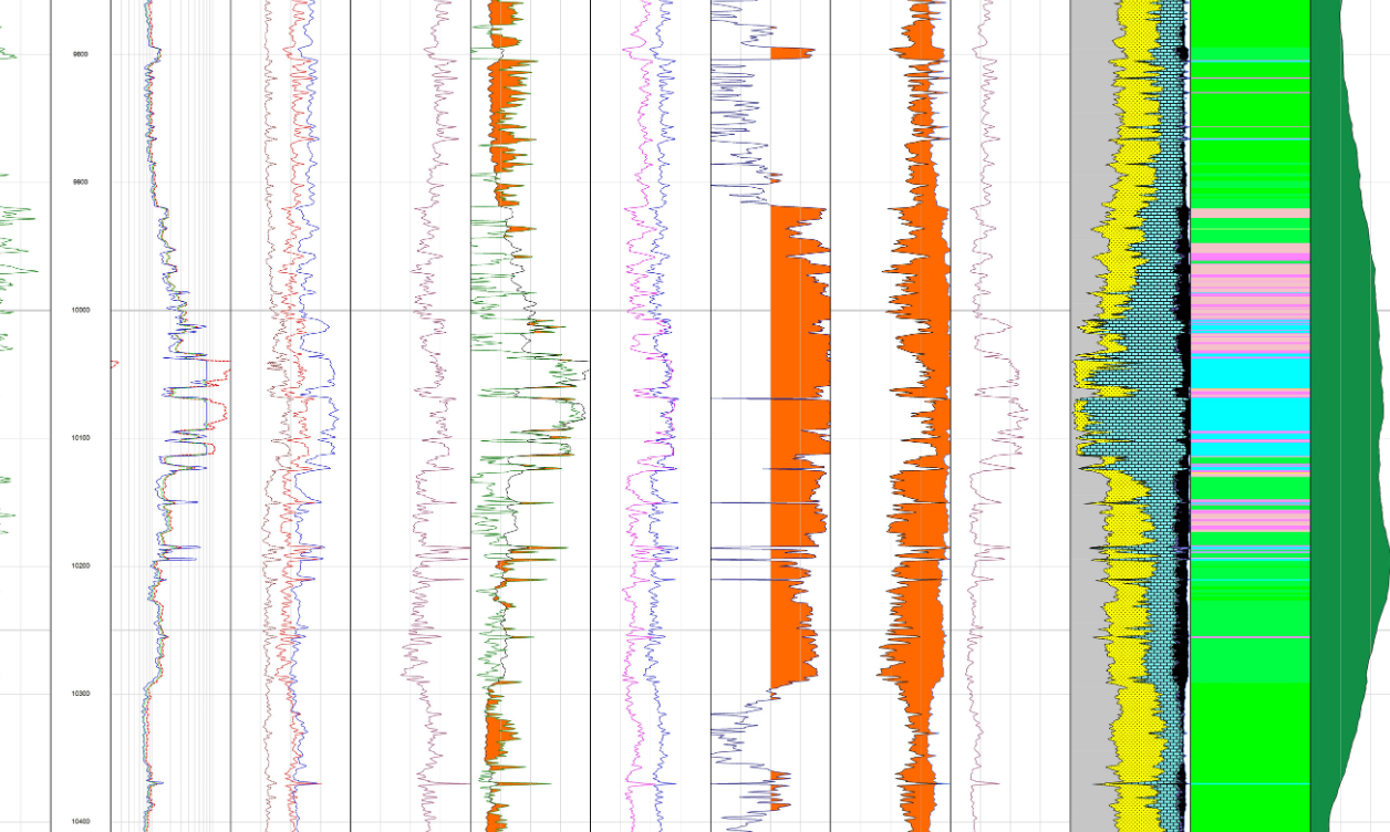
- Depth-calibrated raster logs: Depth-calibrated and easily viewable digital representations from scanned well logs
- Digital LAS logs: 12-Curve log suites to provide the best essential log curves, digitized from top-to-bottom with curves of same name/description merged
- Mud logs: Data from the drilling engineer and well site geologist relating to the rock and hydrocarbons encountered
- Check shot and velocity data: Direct measurement of travel time between the surface and a given depth
- Petrophysical interpretations: Core-calibrated attributes incl. TOC, OOIP, clay volume and more
Development
- Well log digitizing and scanning services: Scanning, indexing, validating, digitizing, and conditioning well logs to the TGS standard and customized specifications
- Subsurface data management: Mastered, secure, and OSDU-compliant solution specifically for well data and geological data
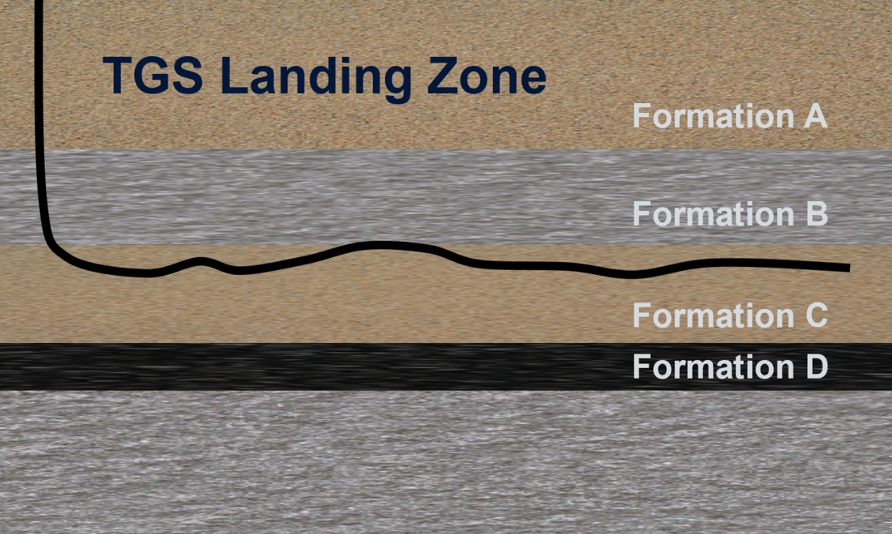
- Interpreted tops and stratigraphic models: Structural grids, temperature models (BTM), and attribute volumes (predicted log responses, petrophysical properties); over two million hand-picked tops in 21 U.S. basins
- Carbon capture and storage: CO2 storage suitability and capacity assessment for depleted hydrocarbon reservoirs and saline aquifers
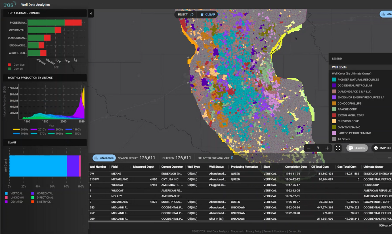
Utilize Well Data Analytics
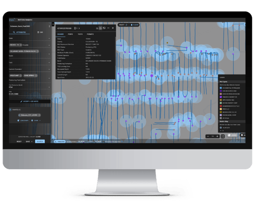
Access our geological data through Well Data Analytics to benchmark, predict, and optimize oil and gas well performance. Our latest software seamlessly integrates production data, geological mapping, powerful visualization, and user-favorite workflows. The platform also provides unparalleled access to an extensive subsurface data library within seconds, supporting efficient on-the-spot analysis. Additionally, predictive analytics for oil and gas enhance decision-making, and the cloud-based well data resources are quality controlled and adaptable for various usage levels.
TGS Geological Data Quality
Our industry-leading library of geological data includes global coverage of rasters, digital logs, and stratigraphic models, providing valuable insights for the best subsurface understanding.

- TGS Validated well header ties the correct data to the correct wellbore
- PPDM and OSDU compliant API numbers
- Workflow-ready datasets, matched with the largest library of well data
- 30% of our database is unique to TGS from proprietary sources
- 23% more rasters than state agencies
- 5x more digital wells onshore, 7 times more digital wells in key basins
- Digitized top-to-bottom
- More than 60 types of well logs:
- Standard: GR/SP, RES, DEN, NEUT, SON
- Speciality: MUD, Lith + comments, composites, check shots, porosity etc.
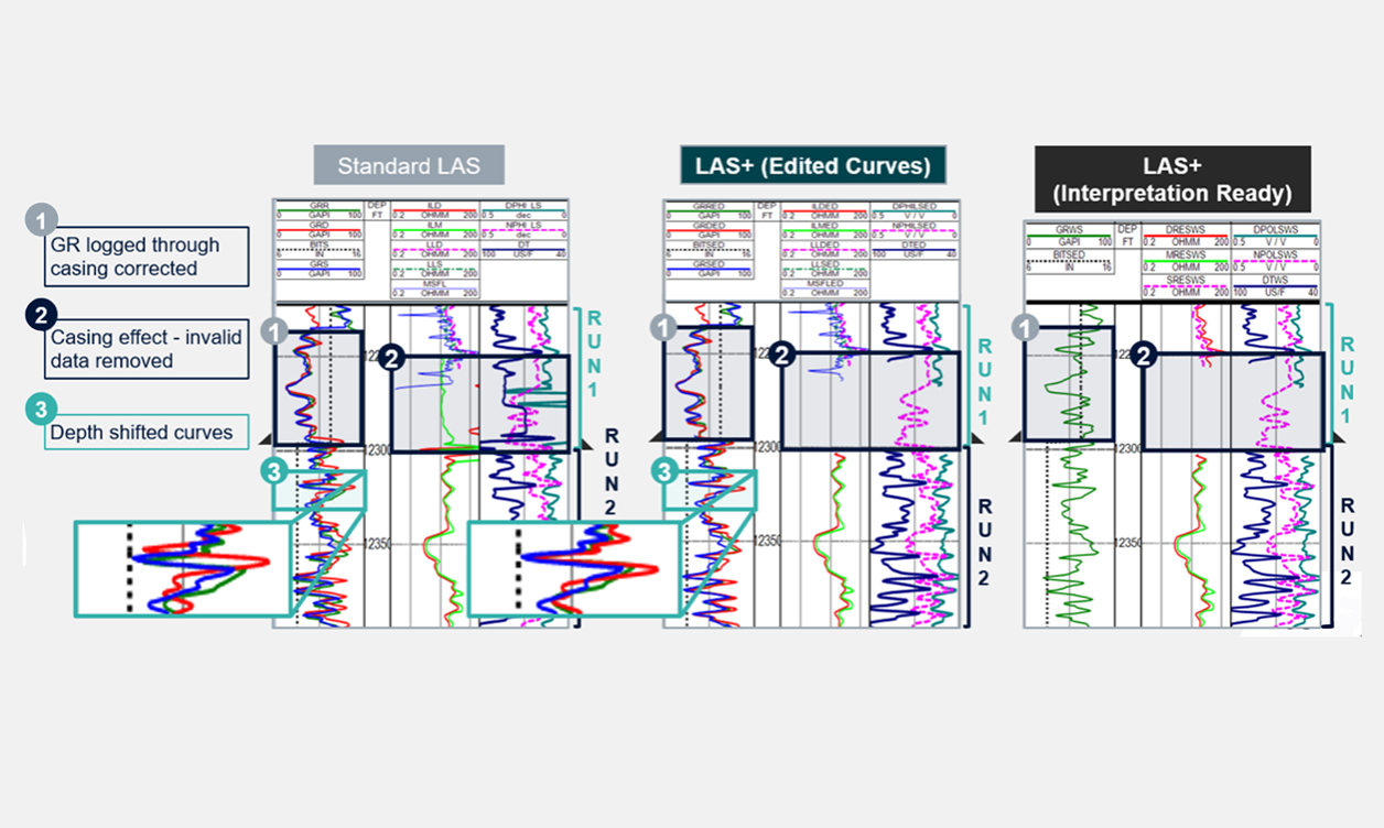
LAS+ Workstation-ready logs: Edited and Conditioned
Start interpreting right away with industry-leading corrected curve data. Leverage the work of our in-house petrophysicists and save hours of processing and preparation time. Available onshore and offshore.
- LAS+ includes only geologically valid logs, depth-shifted, standardized mnemonics, spliced WL and LWD, and removal of invalid data
- Includes original and edited curves that have been cleaned up, depth-shifted, and validated
- Interpretation-ready data that has been consolidated and spliced for maximum depth coverage
- Detailed documentation of available original curves and description of the curve corrections made.
| Top-to bottom digitization of rasters and digital data | Primary curve groups: RES, DEN, GR, NEUT, SON | Curve Class Mnemonic Standardization | Top to Bottom Composited Curves | No incorrect data | All data on depth | |
|---|---|---|---|---|---|---|
| LAS | ||||||
| LAS+ |
Stratigraphic Models
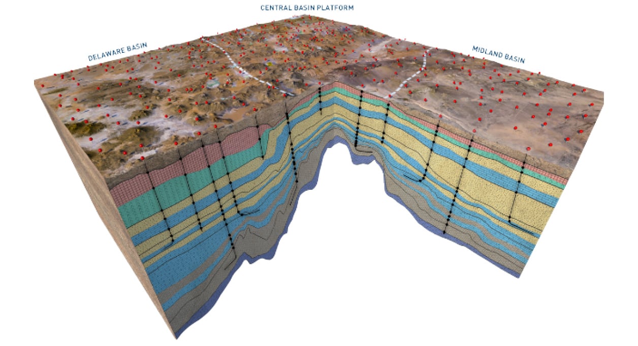
We offer hand-picked interpreted tops across all major U.S. onshore basins derived from the industry’s largest library of well logs.
- Stratigraphic framework interpreted by experts across 21 North American basins
-
Key wells based on spatial distribution and penetration
-
Top-to-bottom picks with emphasis on high-value formations picked by a single geologist per basin
-
Continuous expansion to increase lateral and vertical density to support basin modeling
-
Detailed report for each model including:
-
Geologic history
-
Production statistics
-
Interpretation and QC workflow
-
Basis for top picks
-
Regional cross-sections
-
-
Attribute Volumes:
-
Basin Temperature Model: constructed from formation tops integrated with BHTs from TGS' Stacked Headers
-
Cubes Available: Temperature, Mud Weight, Total Organic Carbon (TOC)
-
Stacked Headers
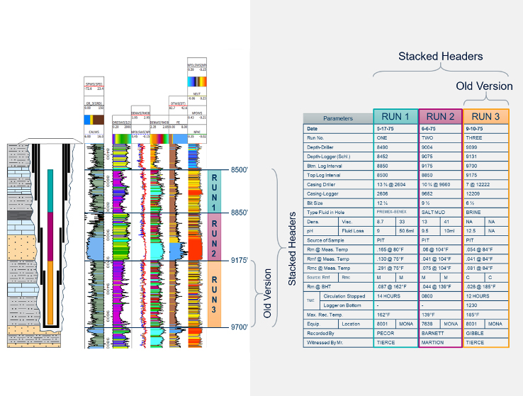
Our stacked headers provide quality log parameters for top-to-bottom log correction and analysis for every run.
- Digitized log header information from all runs instead of only the deepest
- Extensive quality control, ensuring outliers are reviewed and rectified, when necessary, with the focus on providing the data as logged
- Easy consumption within projects
- Including, but not limited to:
- Wellbore diameters
- Temperature measurements
- Drilling fluid properties
- Mud resistivity variations
- Casing characteristics
- Matrix density
Well Data Analytics Free Trial
The Well Data Products Team is here to help
Spend more time analyzing your well data and less time on quality control so that you can make decisions with confidence. Whether you need a complete picture of your well performance or just want to access your well data quickly, our platform has got you covered.
Analytics-Ready LAS: A full quad combo log suite for every well!
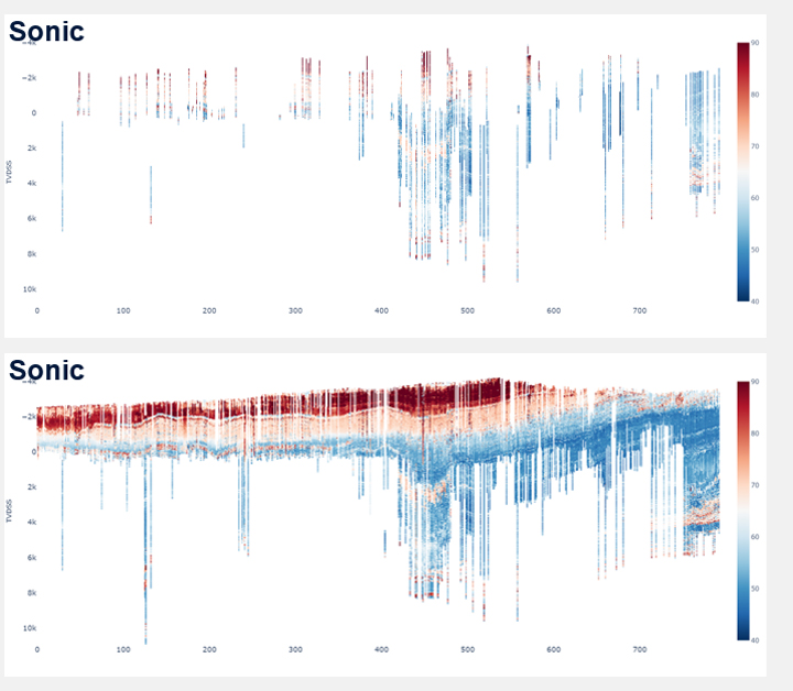
Leveraging the industry’s largest library of log data, our stratigraphic models, and proprietary Machine-Learning models, we predict missing curve data resulting in full quad-combo equivalent curve coverage.
- Model-predicted curves include Gamma Ray, Resistivity, Density, Neutron, and Sonic
- Machine-Learning assisted log clean-up:
- Bad hole identificaiton
- Log splicing
- Bad curve detection
- Unit conversion
- GR spatial normalization
- Mnemonic collision correction
- Machine-Learning model processing
- Post-processing and statistical analysis
- Curve level review and re-prediction
- Well-level review for accuracy
.png)
TGS Well Scanning and Digitizing Services
TGS offers a full turnkey solution including document gathering, processing, and certified destruction. TGS will take your hardcopy and microfiche data and turn it into digital files. Data is associated to the proper API number using our Validated Well Header, and de-duplicated against our extensive commercial log library for cost savings. This service is offered on a proprietary and commercial basis. Incremental or full project delivery to meet your needs.
Core Data
Introducing TGS Core Data, the ultimate source of ground-truth reservoir information, to enhance your petrophysical modeling and subsurface interpretation. Core data serves as the foundation for accurate petrophysical and geological analyses. By utilizing our digitized core analysis reports, you can greatly improve the accuracy and dependability of subsurface data in your projects.
.png)
TGS Geological Data
Our Geological Data provides a trusted foundation for oil and gas exploration decision-making. Our comprehensive data helps guide informed decision-making, ensuring optimized drilling locations and precise reservoir evaluations. Learn more about our offerings' intrinsic value and competitive advantage below.
Quality and coverage matter when assessing the feasibility of reservoir rock and determining drilling locations. TGS geological data is tied to the correct well header by utilizing the TGS Master Data Model. Logs are workstation-ready and can be used in interpretive workflows right away. Subsurface data managers can interrogate the TGS database by using TGS R360 and PPDM and OPSDU-compliant Application Programming Interfaces (APIs).
The geological data offering originates from a multitude of regulatory and proprietary sources. Our library comprises of depth-calibrated rasters, digital logs, petrophysical interpretations, and stratigraphic models. TGS scanning and digitizing services ensure you receive value from your hardcopy data. TGS subsurface data management ensures that all our customers’ data is mastered to the same well header and both vendor and proprietary data is delivered to customers together.
Geological data plays a crucial role in oil and gas exploration as it provides valuable insights into subsurface formations, helping industry professionals make informed decisions regarding estimated reserves, drilling locations, and formation evaluation.
- Raster logs and digital logs provide detailed information about rock formations encountered while drilling. Mud logs provide information about lithological properties and indicate the presence of hydrocarbons. Together, these logs record various reservoir properties such as lithology, porosity, permeability, resistivity, and saturation. This data is essential for identifying potential hydrocarbon-bearing zones and understanding the geological structure of the subsurface to determine the economic viability of potential drilling locations.
- Petrophysical interpretations involve integrating and analyzing various well log data to determine the properties of the subsurface. Petrophysicists combine data from depth-calibrated raster logs and digital logs to calculate the porosity and saturation levels in specific formations. This process helps in characterizing the potential reservoir rock and estimating the amount of hydrocarbons it may contain.
- Stratigraphic models represent the geological layers and their distribution in the subsurface. These models are constructed based on various geological data sources and help in understanding the spatial relationships of different rock formations. Geologists can use stratigraphic models to identify potential traps and reservoir compartments that might hold hydrocarbons. By analyzing the distribution and geometry of different rock layers, they can predict the best drilling locations.
- Basin temperature models are used to estimate the thermal history of a sedimentary basin. They provide information about the subsurface temperature at different depths and times, which is critical for understanding the maturation and migration of hydrocarbons. Petroleum geologists can use basin temperature models to assess the maturity of organic-rich source rocks, which indicates whether they have generated and expelled hydrocarbons. This knowledge helps in targeting areas with high potential for oil and gas accumulations.
A high-quality geological database play a critical role in the planning and management of oil and gas wells, providing a treasure trove of subsurface data that experts in the field heavily rely on. Geological databases such as ours might store information from core samples, enabling experts to gain valuable insights into the geological structures and rock formations beneath the surface.
By utilizing sophisticated subsurface data technology and analytics, you can precisely determine the best well locations and design optimal drilling trajectories to access hydrocarbon reservoirs effectively. Identify fault lines, stratigraphic layers, and potential reservoir traps to inform accurate reservoir assessments.
The integration of geological databases with advanced subsurface data technology can empower your teams to make data-driven decisions, reduce exploration risks, improve drilling efficiency, and maximize oil and gas production.
Speak to a Specialist
Interested in a product demo or trial? Let us know your needs and we’ll connect you to the right person on our Well Data Products team.

