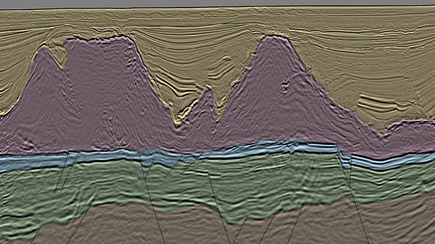
Brazil Pre-Salt Basins Geology
TGS' extensive deepwater dataset over the Campos Basin unveils new geological insights, clarifying complex structures and key petroleum system elements in both pre-salt and post-salt plays.
Our basin study work confirms that pre-salt exploration in the Santos Basin has the potential to yield further significant discoveries.
Revealing New Opportunities in
Brazil's Campos Basin
Many independent oil companies also recognize this potential and the need for high-quality seismic data for upcoming licensing rounds to mitigate exploration risk. Derisking is made possible with this rejuvenated Santos Vision product, which delivers broadband data with superior bandwidth in the pre-salt reservoir.
The Santos basin has seen oil and gas production since the 1970s and remains active as new technology and play concepts reveal far more potential than was originally envisioned. The Brazil pre-salt play fairway is a focus for many companies. Proven reservoir potential is present within the microbiolite and coquinas formations/structures, which contain large hydrocarbon accumulations. Using the Santos Vision dataset, pre-salt carbonate formations can be mapped along the NE-SW fault block trend, which extend into open acreage. Well-defined faults and structures allow for detailed interpretation of traps and prospects, essential for planning an exploration campaign.
This play fairway continues to develop through unitization and bid rounds as recent changes to license terms unlock numerous commercial opportunities allowing existing discoveries within open acreage to become commercially viable. These license changes also rejuvenate post-salt exploration to the north, as Santos Vision covers the post-salt turbidite play, including Tambau and Urugua fields.
The reservoir targets are localized in pre-salt carbonate build-ups underneath the basal anhydrite of heterogeneously layered evaporate sequences and interbedded with volcanic rocks. This challenging geological setting requires innovative seismic solutions. TGS has provided these solutions, with an excellent process for velocity model building and our unique implementation of Full Waveform Inversion utilizing the full wavefield. This FWI pushed deeper than ever before, obtaining robust velocity updates in the pre-salt section and throughout the entire 34,000 sq. km. area.

The Overlooked Present-day Shelf of the Kwanza Basin
Discoveries in the ultra-deep water have bolstered the prospectivity of this area, extending the proven working petroleum system. Seismic interpretation combined with QI analysis has led to the identification of numerous leads and prospects, outlining several presalt trends primed for exploration.
Campos Exploration Development
The Campos basin has been an exploration success in the post-salt for several decades. Inboard, on the pre-salt plateau, fields such as Marlim (1.7bnbbl) have produced vast quantities of oil from post-salt turbidite sand reservoirs, sealed by intraformational mudstones and shales. In the Campos deepwater area, exploration of the post-salt has encountered good reservoir-quality turbidite sands but finding hydrocarbons has proved challenging. Despite this, the attraction of a potential stacked target play combination with the pre-salt is substantial, resulting in an exploration focus extension to deepwater pre-salt plays.
Pre-salt exploration results in Campos deepwater are encouraging. Nearby discoveries prove a working petroleum system in the pre-salt, most notably Pão de Açúcar, which discovered 700 mmbbl of light oil and 3 Tcf of gas. In addition, wells 230 and 554 encountered oil along the inboard edge of the survey. Further east towards the outboard edge of the survey in the ultra-deep water, Urissane and Mairare discoveries confirm that this pre-salt petroleum system extends laterally through the entire Campos deepwater dataset.
The Campos Pre-salt Play
The main source rocks in the Campos Basin are Lower Cretaceous lacustrine calcareous black shales of the Lagoa Feia Group, with the main source kitchen situated within the exterior rift zone and additional smaller source kitchens extending to the north and north-east, separated by structural highs.
The target reservoirs of the pre-salt succession are lacustrine carbonate or siliceous microbialites and coquinas deposited during the rift/sag phase at the late Barremian to Aptian. Focused on structural highs and sealed by Aptian layered evaporites, these formations are easily recognized and mapped by their external geometries and internal seismic facies characteristics.
Complex salt geometries are characteristic of the Campos Basin, influenced by basin structure and morphology which can be divided into three main structural domains; pre-salt plateau, exterior rift zone, and outer basement step (see seismic image below), marking the transition from continental to oceanic crust.
During the Late Cretaceous and Tertiary thermal subsidence of the basin and oceanward tilting caused gravity gliding of the post-salt carapace resulting in the development of salt rollers, Albian fold belt, and mini basins (see image below). The Campos deepwater dataset resolves imaging challenges typically incurred by such salt geometries.
Exploration Shift Towards Outboard: Assessing an Emerging Play
The recent pre-salt discoveries present a new challenge: to determine how far outboard hydrocarbon prospectivity extends. Several models of the structural framework of the distal portion of the basin have been established, and its implications for the petroleum system remain unsettled. For example, the transition from continental to oceanic crust, the presence of hyper-extended continental crust, wedging of the syn-rift sequence, or even exhumed mantle has generated many interpretations.
Revealing Prospectivity with TGS Data
Overall, the Campos Basin holds significant potential for exploration and production, and continued investment will likely unveil new discoveries in the years to come. The exploration success within the Campos deepwater region provides confidence in the group of undrilled prospects mapped on the seismic. These carbonate build-ups and microbial platforms display strong AVO responses and are used to plot and nominate license blocks through the ANP for future Permanent Offer Rounds.
Speak to a Specialist
Interested in a product demo or trial? Let us know your needs and we’ll connect you to the right person or team.
Book a Data Viewing
Want to see the latest seismic data solutions and imaging technologies in your region of interest or for the next license round? Book a data viewing with one of our experts.
Discuss Your Seismic Data Needs
Every need is different and we'd like the opportunity to discuss yours further. Speak to one of our data or geoscience experts to customize seismic solutions specific to your requirements.


