
Atlantic Margin:
New Data Unlocks Exploration Opportunities in the Møre and Vøring Basins


Why the Atlantic Margin?
Norway is well-positioned to contribute significantly to Europe's energy security well into the next decade. According to estimates by the Norwegian Petroleum Directorate, approximately 24 billion barrels of oil equivalent remain undiscovered in Norway's offshore territories. Recent developments have motivated explorers to re-evaluate previously overlooked, gas-prone basins, such as the Møre and Vøring basins in the Norwegian Sea Atlantic Margin. Norway's proximity to the EU market and its capability to support new infrastructure make potential discoveries particularly valuable. The likelihood of significant findings is high due to these favorable conditions.
Exploration efforts were previously hindered by a limited geological understanding of the region, where few wells had been drilled. Geoscientists lacked access to clear, well-defined subsurface images of drilling targets and had insufficient intra- and sub-basalt sedimentology information. Advances in subsurface imaging technology have since resolved these issues, enabling more effective exploration.


TGS now offers over 59,000 km² of regionally consistent, high-quality, modern 3D seismic coverage, acquired since 2017. Our data reveals new sand fairways and pre-Cretaceous highs and identifies 50-60 commercial-sized gas or oil leads. This has opened up new, under-explored plays in both shallow (Miocene-Pliocene) and deeper target intervals, where sill intrusions and basalt had previously posed significant challenges.
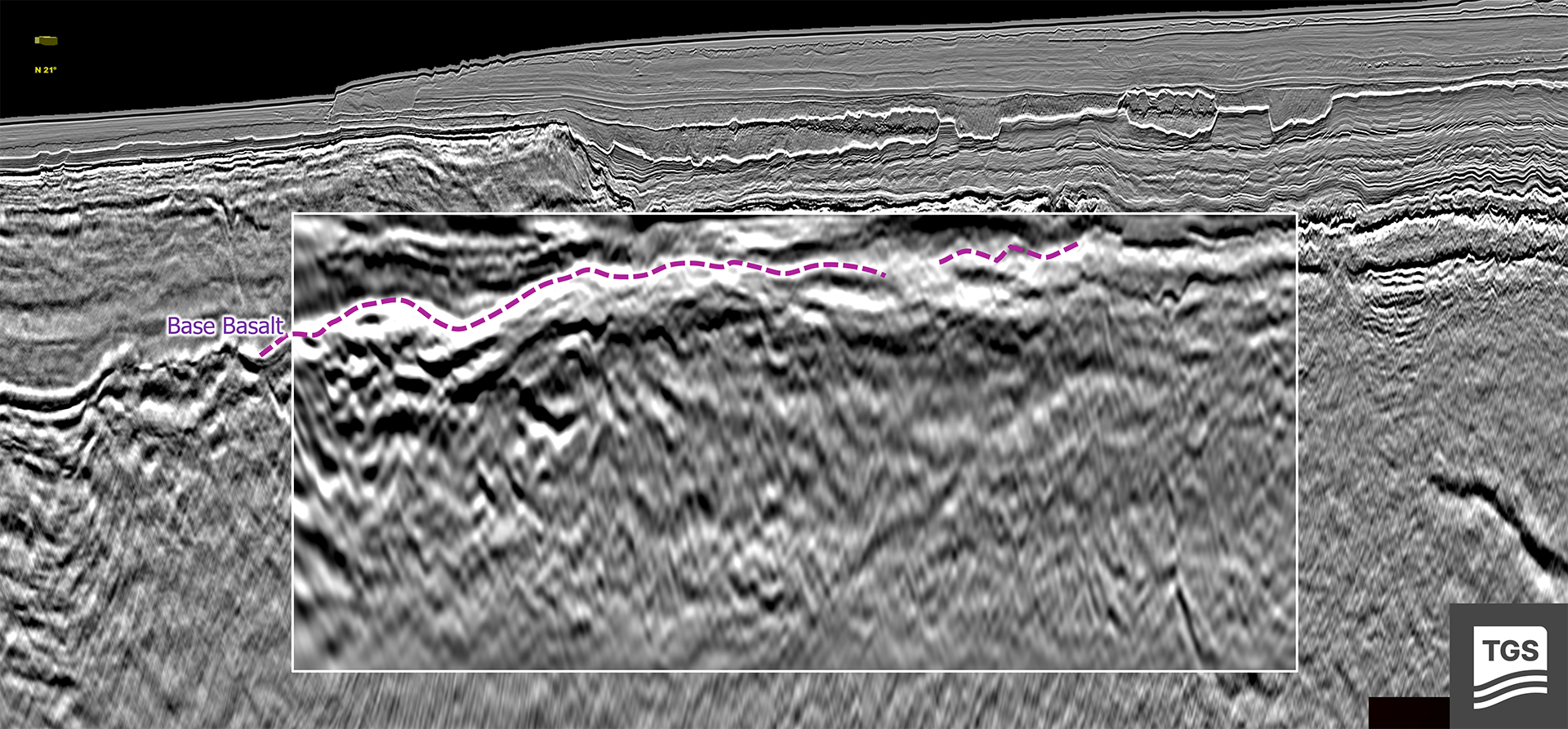
Crucially, TGS seismic technology has succeeded in unveiling prospects hidden beneath complex basalt rock formations. By utilizing advanced seismic imaging algorithms such as Dynamic Matching Full Waveform Inversion (DM FWI) and Common Offset Reverse Time Migration (RTM), we can interpret subsurface velocities with extremely high confidence and greater detail. These techniques enable us to identify specific features, such as terrains of rotated fault blocks, beneath the basalt layers. The slow seismic velocities detected below the basalt suggest well-preserved sediments under various thicknesses of volcanic rock.
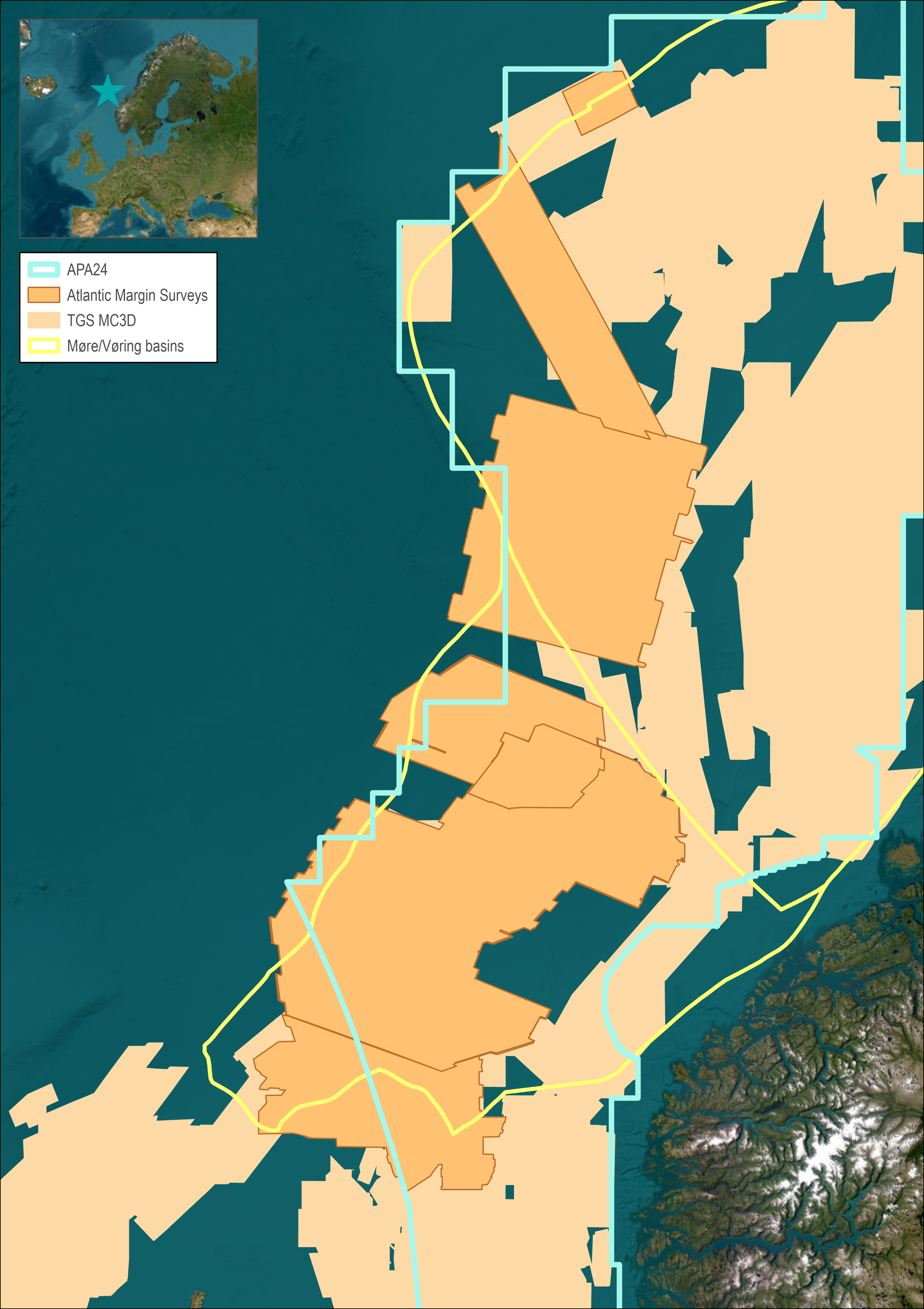
Data Library
Search our interactive map portal to see the industry-leading subsurface data we offer in the Atlantic Margin. View available data types, projects and deliverables in your areas of interest.

Atlantic Margin Seismic Data
- Atlantic Margin 2020 3D Seismic - 8,782 km2
- Atlantic Margin North 3D Seismic - 15,520 km2
- Atlantic Margin North 3D Seismic Phase 2 - 6,789 km2
- Atlantic Margin South 3D Seismic - 31,420 km2
Why Norway? Why Now?
- Modern subsurface data has the complexity, high-end technology, and modeling potential to unlock prospectivity, especially within the basalt.
- The playground (source, reservoir, seal) is in the right place for low-cost exploration.
- An under-explored area the size of the N. Sea. The only area of such magnitude that is still unexplored.
- Cross-border understanding is better than ever. Data ties to a vast well library offshore Shetland.
- Increased confidence in the sands is bringing back major players to the area.
- Volcanics are beginning to indicate positive prospectivity potential.
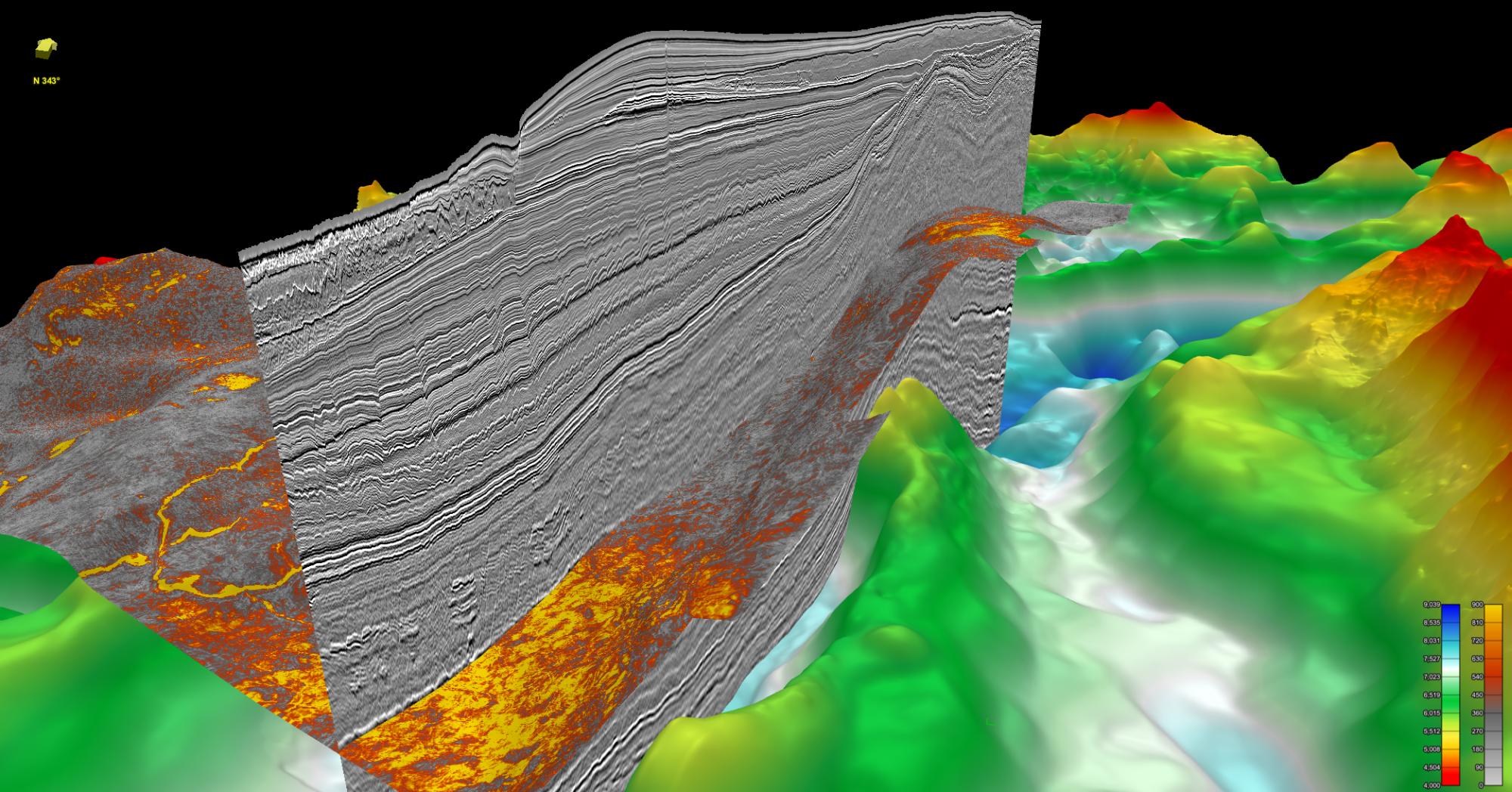
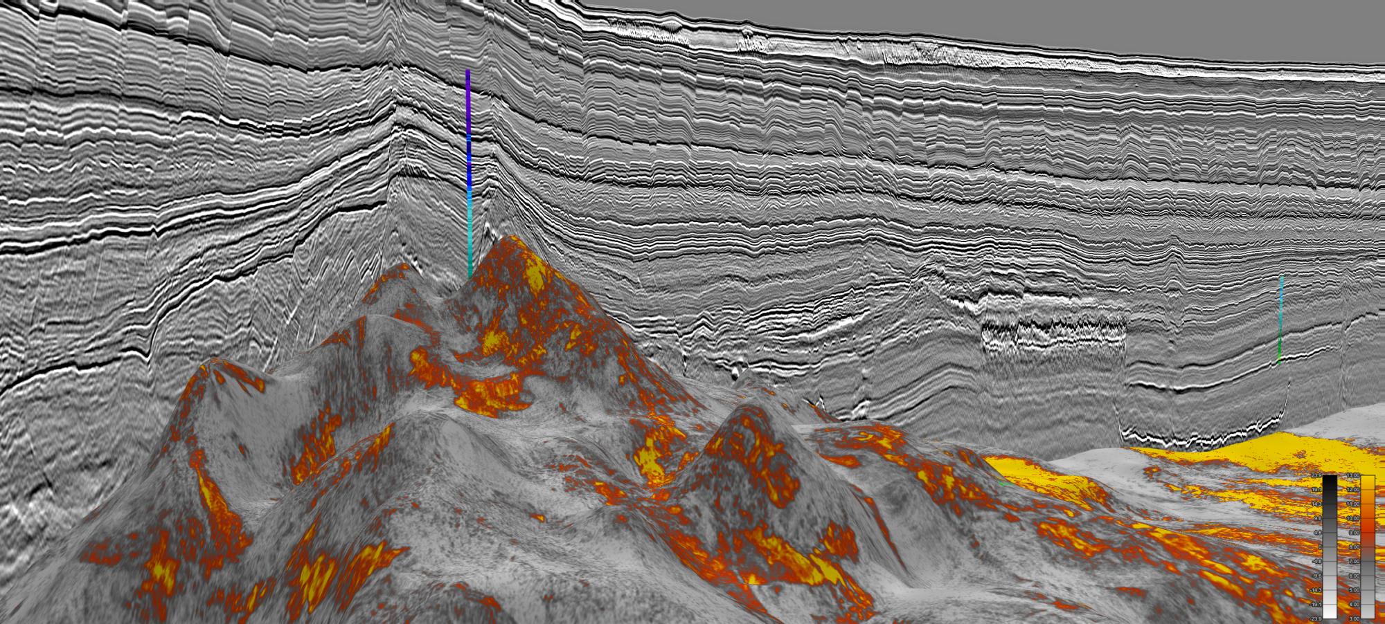
Subsurface visualization from the Atlantic Margin North survey shows significant amplitude anomalies at the Top Lysing level
Dynamic Matching FWI reveals intra- and sub-basalt structures.
New insight gained through the Atlantic Margin data suggests why previous drilling may have been unsuccessful
New Subsurface Insight Reveals Prospectivity
TGS has been a leader in exploration along the Atlantic Margin, from the western Barents Sea in the north to the areas west of Shetland in the south. The Møre and Vøring basins present challenging seismic terrains characterized by soft sediment deformation in the overburden, shallow gas, seafloor slides, and volcanic sill complexes that intrude Cretaceous basins and sub-basalt targets within the Møre and Vøring marginal highs.
Since 2017, TGS has acquired more than 59,000 km² of high-quality 3D seismic data, providing new insights into the volcanic complexes of the outer Møre Basin, sediment-basalt interactions, and sand system distributions. This high-resolution data allows for detailed interpretation of several prospective targets that were previously covered by poor-quality vintage 3D data or lacked data altogether, supporting the planning of new exploration wells.
This project focuses on a region that remains under-explored in terms of drilling despite its proximity to existing infrastructure and markets. Technical successes in the region have discovered oil and gas in Upper Cretaceous and Palaeocene units. The Ellida and Havsule wells indicate an active oil source in the Møre Basin, although the predominant expectation is for gas. The Ormen Lange field, discovered in 1997, exports gas equivalent to 20% of the UK's natural gas consumption.
Speak to a Specialist
Interested in a product demo or trial? Let us know your needs and we’ll connect you to the right person or team.
Book a Data Viewing
Want to see the latest seismic data solutions and imaging technologies in your region of interest or for the next license round? Book a data viewing with one of our experts.
Discuss Your Seismic Data Needs
Every need is different and we'd like the opportunity to discuss yours further. Speak to one of our data or geoscience experts to customize seismic solutions specific to your requirements.