Steerable Sources - Fig3
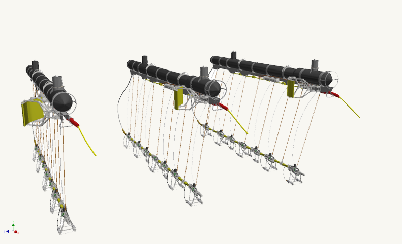
A standard TGS source array with the TGS source steering solution on the front of each float. Two relative GPS (RGPS) towers are mounted on each float. A near-field hydrophone mounted above each mounting location along the source keel is complemented by seven depth sensors along each keel. When combined with the TGS eBird solution for the lateral steering and depth control of each multisensor GeoStreamer, this offers unbeatable precision and repeatability of all source and receiver positioning.

Solutions for Flexible Survey Geometries

All TGS seismic vessels are equipped with steerable source sub-arrays. These minimize lateral deviations in source position and create better-conditioned 4D baseline and monitor surveys.

GeoStreamer uses both hydrophones and velocity sensors to remove all free-surface ghost reflections from marine seismic data. The streamer is towed deep, with a low-drag depth profile to minimize exposure to weather and surface noise. Data is rich in both low- and high-frequency signal, and ideal for high-fidelity reservoir monitoring, broadband imaging at all target depths, and the recovery of accurate geological properties during reservoir characterization.

Highly Repeatable 4D Monitoring Survey Geometry

Steerable source systems improve survey efficiency and increase 4D repeatability by minimizing the effects of variable currents on the acquisition geometry. Each sub-array can adjust to maintain survey pre-plot lines while the vessel optimizes streamer spread locations. The maximum lateral source correction is up to ±4 m from the natural towing position, and the mean lateral source position error from the target trajectory is less than ±2 m.

Computer-controlled adjustable wings on each source sub-array work together to minimize the lateral position error, while also maintaining sub-array separation. Positional data from the GPS and acoustic network sensors deployed on each sub-array are compared with a predefined source pre-plot and a lateral positioning error is computed by the onboard navigation system. This positional error is communicated to the source-steering system, which then computes the required wing angles to steer the source into the correct position. The graphs below are an illustration of position performance for a pre-plot scenario with the source steering system disabled and enabled.

Steerable Sources -Fig1
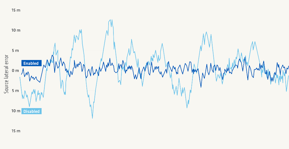
An illustration of the lateral source positioning error with active source steering (dark blue curve) and without source steering (light blue curve).
Steerable Sources - Fig2
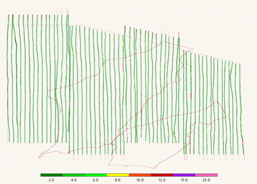
4D monitor survey shot positions color-coded by the crossline source position error from the 4D baseline shot positions.

Maximizing 4D Survey Accuracy

The display to the left shows a real 4D monitor survey vessel pre-plot, where the color scale represents the average lateral-source-position error controlled by a prototype source steering system used in 2014 (now improved). The inline source position error is influenced by the source-firing-time error at each baseline shot position and is usually small. For modern TGS 4D surveys, more than 90% of radial shot-position errors are typically less than 3 m.


Speak to a Specialist

Interested in a product demo or trial? Let us know your needs and we’ll connect you to the right person or team. 

Book a Data Viewing

Want to see the latest seismic data solutions and imaging technologies in your region of interest or for the next license round? Book a data viewing with one of our experts.

Discuss Your Seismic Data Needs

Every need is different and we'd like the opportunity to discuss yours further. Speak to one of our data or geoscience experts to customize seismic solutions specific to your requirements.