

Electrical and EM data can be acquired and interpreted at a range of scales, from regional mapping to reservoir characterization, and from hydrate mapping to ultra-high resolution for shallow contamination mapping and minerals characterization.
Electric and Electromagnetic
Fast and Efficient Data Acquisition
- Dense source and receiver coverage enables high resolution of sub-surface resistivity structure within the system’s depth of investigation
- Data is acquired three times faster than other offshore EM methods, allowing more data to be acquired within a fixed budget
- Can be operated from a vessel of opportunity, in combination with other survey technologies
- Data recorded in real-time on the survey vessel to give an early indication of data & data quality
- No contact with the seafloor, and transmitted fields have little to no effect on marine wildlife in the survey area
Large Scale Acquisition of High-Quality Marine CSEM Data in a Fast and Efficient Manner with Minimal Environmental Impact
The towed-streamer EM system was developed by TGS and first deployed commercially in 2009 for hydrocarbon exploration. Since then, over 20 000 line km of EM data have been collected. OFG acquired the system in 2021. The towed-streamer EM system uses a high-powered horizontal electric dipole source that is towed behind a survey vessel to transmit EM fields through the seawater column and into the seafloor. The resulting signals are recorded by an array of electric field receivers, also towed behind the survey vessel. This configuration provides a fast and efficient way of acquiring high-resolution CSEM data at a significantly lower cost than other EM methods, paving the way for large area surveys in parallel with seismic programs.
At intermediate scales, using the deep-towed Vulcan CSEM data system developed at the Scripps Institution of Oceanography, OFG has acquired over 1000 line km of data mapping marine gas hydrates as both a hazard and potential resource. Other applications at this scale include permafrost mapping and site survey and characterization.
At ultra-high resolution, an AUV-CSEM method provides meter-scale information on the resistivity of the shallow subsurface to depths of a few tens of meters. Applications include detailed mapping of seafloor mineral deposits and high-resolution imaging of sub-surface contamination.
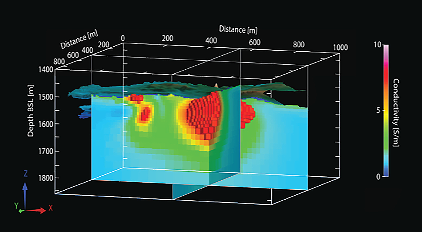
Inverted conductivity model from deep towed CSEM data.
Oil & Gas Applications
Other Subsurface Applications

Offshore Groundwater Mapping
Globally, there are increased pressures on traditional freshwater supplies. Offshore groundwater resources could potentially provide very large additional reserves, however, these remain poorly understood. Recent proof-of-concept surveys have demonstrated how EM may be used for the detection and characterization of offshore groundwater resources. The OFG towed-streamer EM system is ideal for mapping subsurface resistivity data across extended areas on continental shelves. Once acquired, multiphysics approaches that were developed for reservoir characterization in the oil and gas industry can be used to make a quantitative estimate of new freshwater resources that may help to address critical water shortages.
Understanding the Effects of Climate Change
Numerous studies have indicated that Arctic permafrost may be thawing in response to global changes in climate and rising sea levels. Such thawing affects the hydrogeology and ecology of the region and is a likely source of large to huge emissions of methane, a potent greenhouse gas. Understanding the extent of the permafrost (and any associated methane hydrate), its stability, and how these change over time is therefore a key goal in understanding the effects of climate change on the Arctic region. Electromagnetic methods have proven effective at mapping permafrost and methane hydrates on continental shelves. The towed-streamer EM system can rapidly map resistivity in such areas, providing accurate measurements of resistivity from which permafrost extent can be estimated.
Environmental Mapping
Release of contaminants into the environment is to be avoided at all costs. However, should the worst happen, it is important to understand the extent of the contamination and how it varies over time, in order to design effective mitigation strategies and verify their effectiveness. In many settings, electrical resistivity, mapped using a towed-streamer EM system, provides a non-invasive method for evaluating the spread and concentration of any contamination. This becomes increasingly important as a growing number of offshore hydrocarbon production facilities head towards a decommissioning phase.
Gas Hydrate Mapping as a Resource or a Hazard
Marine gas hydrates and shallow gas can be seen as either a resource or a hazard depending on context. In both cases, surveys have demonstrated that such accumulations can be mapped using EM methods. The towed-streamer EM method allows efficient mapping of such features over a wide area.
Seafloor Mineral Mapping
Mineral deposits are typically highly conductive compared to the host rock, a property that is used extensively in mapping onshore research. Ultra-high-resolution CSEM methods can be used to map the presence and extent of conductive ore bodies in the subsurface as part of a characterization and reserve estimation workflow. In passive mode, ambient electric fields can be measured in regional or local surveys to understand self-potential, which is indicative of hydrothermal activity and mineralization.
Speak to a Specialist
Interested in a product demo or trial? Let us know your needs and we’ll connect you to the right person or team.
Book a Data Viewing
Want to see the latest seismic data solutions and imaging technologies in your region of interest or for the next license round? Book a data viewing with one of our experts.
Discuss Your Seismic Data Needs
Every need is different and we'd like the opportunity to discuss yours further. Speak to one of our data or geoscience experts to customize seismic solutions specific to your requirements.