Offset-azimuth Coverage Links to Depth Imaging Workflows

In benign structural settings with clastic, chalk, or carbonate geology, multi-azimuth acquisition and imaging are often sufficient to overcome spatial variations in target illumination and the simple scattered noise that can corrupt conventional imaging workflows.
 

Achieving Uniform Sampling in Difficult Survey Scenarios

The offset-azimuth coverage for multi-azimuth surveys (refer to the rose diagram below) is characterized by reasonably continuous azimuthal coverage for the shorter offsets, and quite abrupt azimuth contrasts at longer offsets. For complex structural settings compounded by laterally extensive and rugose salt bodies, complex wavefield propagation effects can create complex coherent noise and significant target illumination variations that render conventional imaging workflows quite useless.

High-end shot-domain imaging workflows using reverse time migration (RTM) can be more successful when more uniform offset-azimuth coverage for all offsets is acquired using multi-vessel wide-azimuth configurations or well-sampled ocean bottom node deployments.

In cases where ultra-long offsets, longer than maybe achievable using dual-vessel extended long offset survey designs, are required for FWI to provide the deep models necessary for RTM imaging, a combination towed-streamer and OBN survey strategies may be necessary. This can provide the ultra-long offsets for FWI to high-grade the subsalt imaging, or hybrid streamer-OBN acquisition with the simultaneous deployment of towed-streamer and OBN sensors may yield the necessary offset-azimuth sampling.

In the most challenging scenarios, standalone OBN acquisition with dense OBN spacing, large receiver arrays and significantly larger shot grids represent the most uniformly sampled data platform, though also the most expensive.


Azimuth Sampling - Fig1
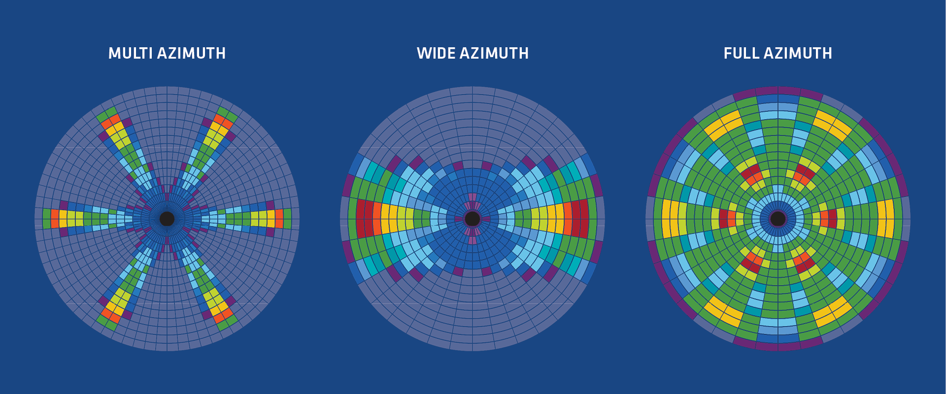
Rose diagrams for a three-azimuth MAZ survey (left), a WAZ survey (center), and a FAZ survey (right). A MAZ survey combines two or more NAZ surveys acquired by a single vessel, but with different survey azimuths. A WAZ survey uses two or more vessels to acquire a larger range of azimuths for each shot. Conventional WAZ shooting acquires parallel lines with one survey azimuth. A FAZ survey applies a WAZ vessel configuration to a MAZ shooting template and acquires the most continuous range of azimuths for all shots.

Speak to a Specialist

Interested in a product demo or trial? Let us know your needs and we’ll connect you to the right person or team. 

Book a Data Viewing

Want to see the latest seismic data solutions and imaging technologies in your region of interest or for the next license round? Book a data viewing with one of our experts.

Discuss Your Seismic Data Needs

Every need is different and we'd like the opportunity to discuss yours further. Speak to one of our data or geoscience experts to customize seismic solutions specific to your requirements.