
Unlocking Subsurface Clarity:
Harnessing the Power of UHR3D and OBN for Carbon Storage Solutions
Across the carbon storage value chain, TGS supports the carbon capture and storage (CCS) industry with informative and innovative decision-enhancing data and insights. Nowhere is this better illustrated than in our combined ocean bottom node (OBN) and ultra-high resolution 3D ("UHR3D") streamer acquisition to create a hybrid monitoring solution for the Sleipner CO2 storage plume.

Why UHR3D and OBN?
For carbon capture and storage (CCS) projects, precise geological characterization, risk assessment for CO2 leakage, confirmation of storage integrity, and monitoring of CO2 plume movement are all vital tasks. CCS fields are often situated in shallow water environments (<100m) that pose unique operational and geophysical challenges.
TGS has developed a ground-breaking hybrid seismic acquisition solution to address these challenges using high-resolution mini-streamers, known as 'UHR3D,' in conjunction with ocean bottom nodes (OBN). This innovative approach overcomes the limitations of near-surface complexity, shallow water operations and operations in congested areas. Our technology mitigates artifacts by leveraging full waveform inversion (FWI) seismic imaging. It enhances the accuracy of velocity model estimation, which is crucial for effective monitoring and risk assessment in CCS projects.
With UHR3D and OBN technology, we offer unparalleled subsurface clarity with strong repeatability, empowering our clients to optimize their CCS initiatives confidently and efficiently.
How Does Hybrid Acquisition CCS Work?
In a groundbreaking technology demonstration project conducted in 2022 over the Sleipner CO2 storage facility offshore Norway, TGS and its partners showcased the efficacy of hybrid acquisition methodology. This innovative approach combines the power of UHR3D acquisition with OBN capabilities, maximizing imaging potential and acquisition efficiency.
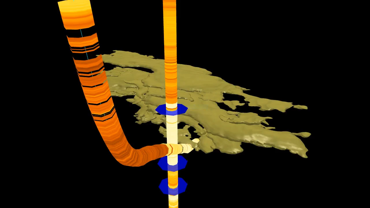
As part of the survey, a strategic grid of nodes was deployed, capturing data simultaneously with UHR3D shots fired from the UHR-3D streamer vessel, forming what's known as a 'shot carpet' with offsets of up to 5 km. To demonstrate cost-efficiency, this sparse node grid was selected to cover the overall extent of the CO2 while limiting the number of nodes required.
The UHR3D system was configured with twelve closely positioned short streamers spaced 12.5 meters apart. Each streamer had a 150-meter active section with 48 channels spaced 3.125 meters apart. This setup enabled towing the source and receiver spreads deeper than usual, enhancing operational efficiency by minimizing weather-related downtime and reducing noise in the data. A small source volume was also utilized to reduce the environmental impact and equipment footprint. With the dense receiver arrays and the high sampling rate, the required spatial and vertical resolution can be achieved and meet the imaging requirements in CCS projects, particularly in generating high-resolution images of the overburden and CO2 plume level.
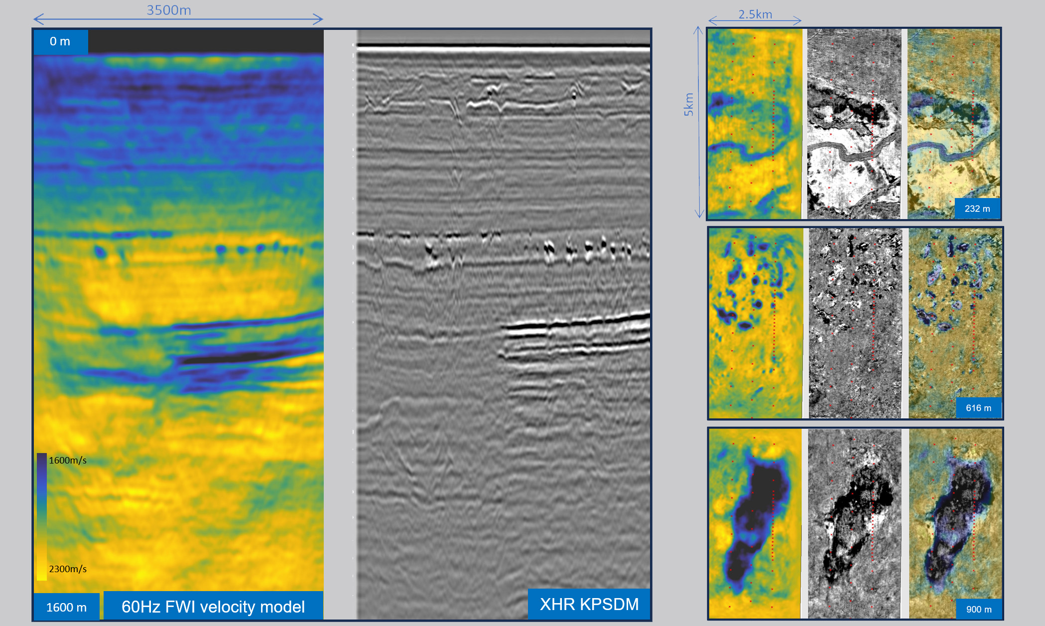
To maximize resolution, the UHR3D dataset undergoes meticulous pre-processing involving iterative refinement of the imaging workflow to optimize image quality. Meanwhile, velocity model building leverages the OBN dataset, utilizing long offsets for precise modeling. Meanwhile, velocity model building leverages the OBN dataset, utilizing the full wavefield (refractions, reflections and multiples) and long offsets for precise modeling with Full waveform Inversion (FWI).
Improved CCS subsurface insight with advanced Ocean Bottom Node technology
Make data-driven decisions with ease. Our technology significantly improves subsurface imaging to de-risking and monitoring CO2 storage sites

What are the advantages of this solution?
This innovative solution offers multifaceted benefits that streamline acquisition processes and enhance subsurface clarity, making it a game-changer for CCS initiatives.
From an acquisition standpoint, deploying, acquiring, and recovering the OBN dataset utilizing free-fall and self-recovery technology eliminates the need for a costly remotely operated vehicle (ROV). This slashes turnaround time and significantly reduces expenses, which are crucial factors in the cost-effective implementation of CCS solutions.
UHR3D short streamers allow operations in very shallow water, while the deep tow capability improves efficiency in challenging weather conditions. These small-footprint acquisition platforms also perform well in obstructed near-shore waters in heavy shipping lanes, wind parks and other congested areas.
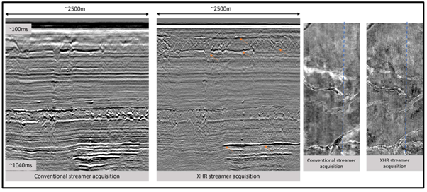
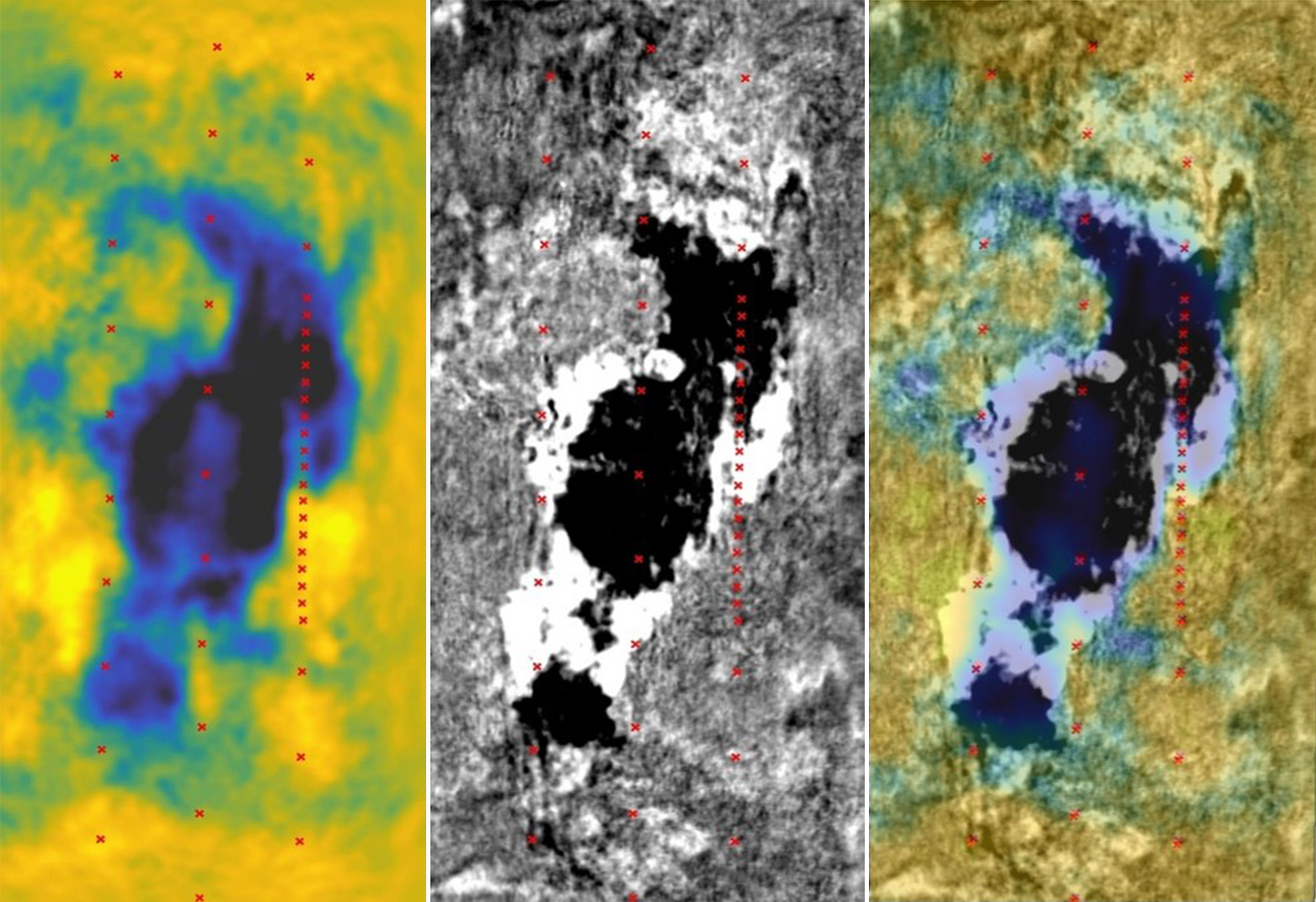
The advantages are equally striking in terms of subsurface clarity. The CO2 plume is impeccably imaged, with individual layers vividly discernible within the broader structure. This clarity extends to the lateral continuity of events and structural details, surpassing conventional imaging standards.
Final imaging results demonstrate a remarkable enhancement in the high-resolution UHR3D dataset, thanks to innovative velocity model-building methodologies facilitated by the long-offset, multi-azimuth, sparse OBN dataset. This uplift in imaging quality is achieved without inflating costs, thanks to the efficiency of the hybrid acquisition approach employed.
A reflectivity image of the subsurface can also be derived from the FWI workflow, providing a complementary dataset with better signal-to-noise and events continuity to strengthen the interpretation of the CO2 plume and overburden risks. With the evolution of high-end FWI imaging tools and the introduction to elastic assumptions, better and more accurate velocity models and FWI Images can be achieved, providing the capabilities to extract additional seismic attributes and estimate reservoir properties. This hybrid method enables high-resolution imaging and facilitates long-offset velocity model building, both indispensable for robust CCS monitoring solutions.
Recognizing the economics of CCS endeavors, this cost-effective fusion of UHR3D and OBN data emerges as a pivotal component in 4D monitoring strategies for CCS projects, ensuring both efficacy and cost-effectiveness.
A Complete CCS Toolkit
Navigate operational, geological, and geophysical complexities seamlessly with comprehensive carbon storage mapping and monitoring solutions. Gain unparalleled subsurface understanding with an extensive array of CCS storage surveillance tools from a trusted leader in geophysics.
We offer both conventional seismic solutions utilizing streamer and node technologies and groundbreaking new and hybrid solutions explicitly tailored for Carbon Storage monitoring.
Partner with us for all your carbon storage mapping and surveillance needs.
Speak to a Specialist
Got a question? We're here to help. Drop us a line and provide your contact details so one of our energy data experts can get in touch with you.