
First Published: The Leading Edge, March 2025 by Bertrand Caselitz, Allan McKay, Martin Widmaier, Julien Oukili, Daniel Davies, and Noemie Pernin, TGS
Abstract
The global transition toward renewable energy has intensified the demand for more offshore wind power generation. Advanced geophysical techniques to enhance near-surface site characterization and ensure the rapid, safe, and efficient installation of wind turbines are of considerable value. Traditional 2D ultra-high-resolution seismic (UHRS) methods, while useful, generally lack the resolution and spatial coverage required for modern offshore projects. Depending on the requirements, 2D surveys are often acquired over multiple years. In contrast, 3D UHRS technology, acquired in a single campaign, provides detailed and comprehensive subsurface data, significantly improving the reliability of ground models. This article highlights the value of 3D UHRS technology in offshore wind farm development, demonstrating the importance of an integrated approach to survey design, acquisition, and data processing and how this enhances subsurface imaging, reduces uncertainties, and supports more informed decision making. The technology’s ability to capture volumetric data across an entire survey area or along corridors allows for the accurate mapping of critical geological features, such as key soil units and hazardous objects (e.g., shallow gas and boulders). The expanded 3D UHRS volume offers flexible options for adjusting turbine locations if any anomalies are detected at the initial sites. Furthermore, 3D UHRS subsurface data provide the reliable framework required for quantitative interpretation, particularly in predicting soil properties, thereby optimizing foundation designs and reducing the need for extensive geotechnical investigations. Most importantly, an integrated 3D UHRS solution can reduce the time required for new wind farm developments to become fully operational and deliver clean energy to consumers.
Introduction
The global push toward renewable energy sources, especially offshore wind, has necessitated the use of advanced geophysical techniques for site characterization. Not only are the number of offshore wind farm projects significantly increasing, but their areal extent is also increasing. Offshore wind developments require detailed knowledge of the subsurface, known as a ground model, to ensure the structural integrity and longevity of wind turbines and their foundations. The complexity of the near-surface environment, coupled with the need for rapid and accurate assessments, has driven the development and application of 3D ultra-high-resolution seismic (UHRS) technology.
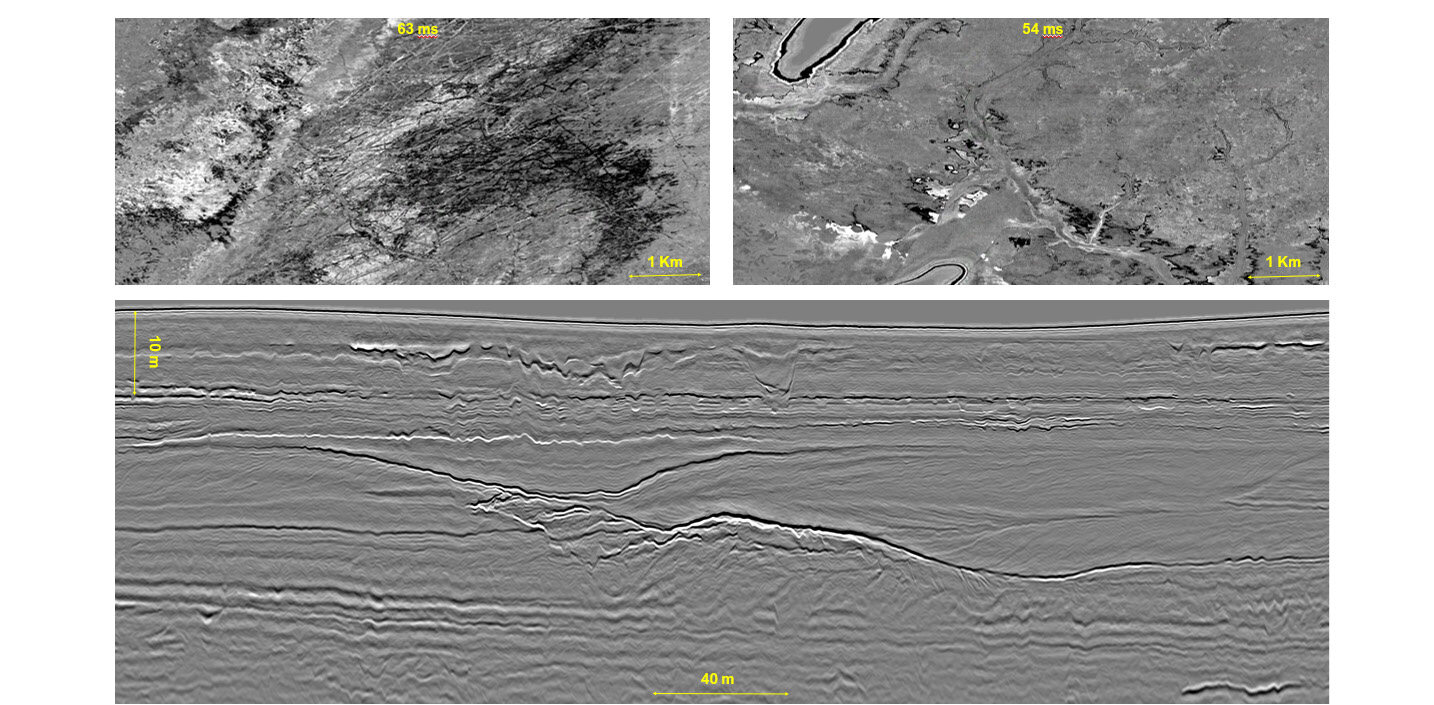
Figure 1. Three-dimensional migrated stack: two time slices on the top and a section at the bottom.
Traditional 2D seismic methods, while useful, often lack the resolution and spatial coverage required for modern offshore projects. As wind developments grow in size and number, the limitations of 2D surveys, such as incomplete subsurface images and lower resolution, become increasingly apparent. In contrast, 3D UHRS surveys offer the ability to comprehensively characterize subsurface structures, properties, and potential hazards, enabling more reliable and robust site assessments (Figure 1). The continuous 3D data set offers more accurate interpretation of the soil units compared to a 2D data set. Additionally, it facilitates the detection of small-scale features like boulders or shallow gas pockets that could pose significant risks during turbine foundation work and any geotechnical sampling. A 3D UHRS volume is expected to deliver high-quality input data that enable more detailed quantitative interpretation (QI), aiding in the estimation of soil properties and the development of a comprehensive ground model.
Read the full article here.